Monitoring
When working on a Monitoring-concept the the following questions should be considered.
How can a CO2 leak be detected on the seafloor?
CO2 reservoirs need to be monitored to detect CO2 leakage at an early stage. In recent years, a number of methods have been developed and tested in practice to detect CO2 leakage at the bottom of the North Sea.
These monitoring methods have been intensively investigated at the European level within the ECO2 and STEMM-CCS (Sub-seabed carbon dioxide storage) projects. It was found that multibeam echo sounders are particularly suitable, as these devices can be used to locate and measure gas leaks even at low levels and over a wide area. In addition, chemical sensors can be used to detect and quantify CO2 dissolved in soil water. The multibeam echo sounders and chemical sensors can be deployed on both ships and autonomous underwater vehicles to provide regular monitoring (AIMS3 project). However, the approach of the GEOSTOR project is to detect and map potential leaks and leak paths at an early stage, before CO2 leakage occurs on the seafloor. The active seismic methods used for this purpose so far only provide snapshots of CO2 propagation in the subsurface and lead to considerable noise pollution, which can affect e.g. marine mammals (environment). In GEOSTOR, therefore, passive seismic is being further developed and used to detect micro-earthquakes and observe physical changes in the rock, as well as to visualize CO2 propagation in the storage formation.
How can the development of pressure in the storage formation be monitored?
Permeable storage formations (e.g. sandstone) covered with impermeable barrier layers (e.g. mudstone) are used for CO2 storage. The goal is to achieve uniform CO2 dispersion (distribution) in the permeable storage formation while preventing CO2 from escaping from the storage.
The pressure development in the storage formation is thereby evaluated based on the pressure that must be applied to bring the CO2 into the storage formation (injection pressure). In addition, pressure sensors are installed in the storage tank to measure the pressure directly in the storage tank. Storage must be stopped if the pressure increases too much, i.e., exceeds predetermined limits. This problem can occur if the reservoir formation is less permeable than expected. Significant pressure changes in the rock volume can result in geomechanical changes in the rock volume that can lead to the development or reactivation of fractures, cracks, and faults. This localized splitting of the rock triggers small microseismic events that can be detected by ocean-bottom seismometers on the seafloor. This passive, non-invasive seismic method can be used to detect changes in the occurrence of these microseismic events over time. The distribution of microseismicity characterizes preferred flow paths and zones where subsurface barriers are breached. This method should significantly reduce costs as well as intrusions into the natural environment and allow CO2 dispersion to be recorded over a larger area and over time.
Can CO2 dispersion in the subsurface be visualized?
The dispersion of CO2 in the storage formation can be tracked using geophysical methods. This approach has already been successfully applied to CO2 storage in the Norwegian North Sea (Sleipner project). So far, active seismic methods have been used, which are very informative but may disturb harbor porpoises and other marine mammals due to the significant noise generation (environment). In addition, the reservoir is only imaged for a short time.
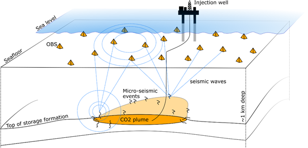
The GEOSTOR project is therefore developing a new environmentally friendly and minimally invasive method to track CO2 dispersion and detect changes in the subsurface at an early stage. For this purpose, ocean bottom seismometers (OBS) are installed on the seafloor to record seismic velocities and microseismic events in the subsurface (“mini-earthquakes”). The subsurface microseismic events can be monitored using the OBS and full wave location technology, which record the seismic moment tensor in the rock using the full waveform signal registered on three components (x, y, z) of the OBS with the lowest signal-to-noise ratio. These microseismic events may be due to pressure changes, fluid shifts, pore fluid saturation, reactivation of fractures and filtration channels. Therefore, the method does not require active seismic sources, and little ship time is required to set up and maintain the OBS, so there is no significant noise disturbance (space planning). Each deployed OBS continuously records seismic data and thus also provides a continuous assessment of the condition of the reservoir.
How can the large amount of continuously recorded data be processed?
Automated and optimized interpretation of the data is a prerequisite for an industrially scalable and socially acceptable monitoring system (monitoring, measurement and verification) of CO2 sequestration in offshore reservoirs.
The amount of data generated is increasing over time, especially for long-term projects and with the increasing number of CCS projects planned worldwide to achieve the net-zero target and mitigate climate change. These growing volumes of data must be processed efficiently to ensure timely interpretation of the data to mitigate the risks associated with CO2 storage. The project will develop new ways to efficiently analyze the large amounts of data generated by this passive seismic method. Approaches from the field of artificial intelligence (AI) will also be used to automate and qualitatively improve the analysis of seismic events. Methods for scalable processing in the cloud are being developed for optimized and fast data processing. Data processing and interpretation methods will be optimized using passive seismic datasets acquired during storage projects.
In addition, the layout and technical configuration of the OBS will be optimized to ensure good coverage of the storage formation. CO2 and pressure dispersion results based on simulations of CO2 storage in the two GEOSTOR work areas will be used for this optimization (Geology).
Why is a new monitoring methodology being developed in GEOSTOR?
The goal of this new technology development is to achieve continuous monitoring of three-dimensional CO2 expansion in the subsurface without affecting the marine environment. In addition, the cost of CO2 monitoring should be extremely reduced (space planning). In addition, seismicity can be used to detect geotechnical risks at an early stage (environment)
Overview of a marine passive seismic monitoring system that provides a continuous record of the seismicity of the CO2 storage formation.
Team:
Dr. Florian Schmid (K.U.M)
Arne Schwenk (K.U.M)
Philipp Kraus (TO – Big Data Prozessierung und Skalierung)
Further Information:
https://www.trueocean.io
https://www.kum-kiel.de
https://www.tenzorgeo.co.uk